
WASHINGTON — Thursday won't be a washout, but you'll want to keep an umbrella handy for two rounds of wet weather.
Quick Forecast:
Tonight: Mostly cloudy and mild with rain arriving late. Low: 68.
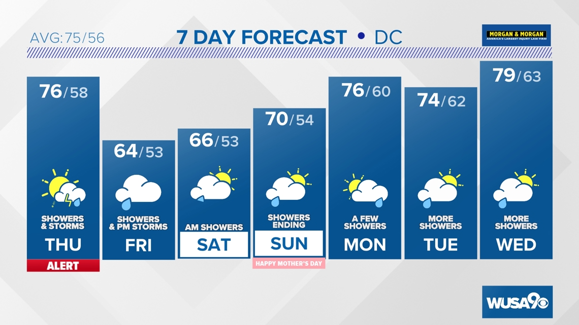
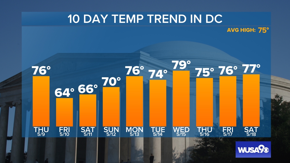
Thursday: AM showers/storms and cooler with more showers and storms late. High: 76.
Thursday Night: Cooler with showers and storms tapering off. Low: 58.
Friday: Partly sunny and much cooler with isolated PM showers and storms possible. High: 64.
We're tracking more showers and storm chances for Thursday that will come in two waves - the first during the morning commute and the second later Thursday evening. Everyone will see light rain in the morning hours, but the evening storms will be more scattered.
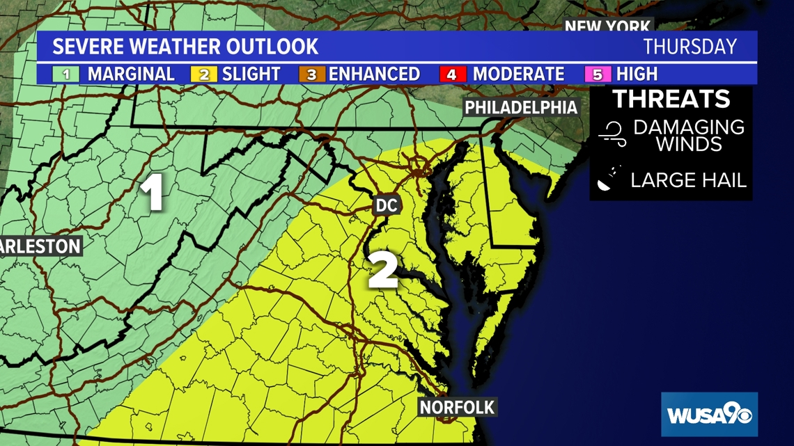
We will be monitoring the potential for strong and possible severe storms embedded in the evening round of rain. The Storm Prediction Center currently has areas along and east of I-95 under a level 2 out of 5 risk for severe storms with the biggest threat being damaging wind and some hail.

The storms will be triggered by a cold front that will usher in much cooler temperatures for Friday. Dress for the upper 50s and low 60s! Yet another round of scattered showers and a few embedded storms looks likely for Friday night.
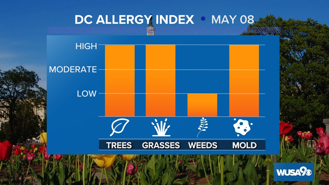
Here is the latest pollen report:

Detailed Forecast:
Tonight: Mostly cloudy and mild with rain arriving late. Lows: 60s. Winds: ESE 10.
Thursday: AM showers/storms and cooler with more showers and storms late. Highs: 72 - 77. Winds: ENE 10.
Thursday Night: Cooler with showers and storms tapering off. Lows: 52 - 62. Winds: ENE 10.
Friday: Partly sunny and much cooler with isolated PM showers and storms possible. Highs: 59 - 64. Winds: NE 10.
A few showers look to linger into Saturday morning but most of the day will be dry before another round of showers return later at night.
Mother's Day will also be mainly dry with the exception of a few scattered showers early in the day. Both weekend days feature temperatures below average in the mid 60s and low 70s.
It will start to feel more like May next week with daily high temperatures returning to the mid to upper 70s. While no day looks like a washout, we will once again be dodging rain drops every day through Wednesday.
Extended Forecast:
Saturday: Mostly cloudy and cool with a few showers possible, mainly in the morning and late at night. Highs: 62 - 67.
Sunday: Mostly cloudy and breezy with spotty showers. Highs: 67 - 72.
Monday: Partly cloudy and milder with a few showers. Highs: 73 - 78.
Tuesday: Mostly cloudy a touch cooler with scattered showers. Highs: 70 - 75.
Wednesday: Partly sunny and warmer with more scattered showers. Highs: 75 - 80.


MORE WAYS TO GET WUSA9
DOWNLOAD THE WUSA9 APP
Apple App Store: WUSA9 News on Apple
Google Play Store: WUSA9 News on Android
HOW TO ADD THE FREE WUSA9+ APP TO YOUR STREAMING DEVICE
ROKU: add the channel from the ROKU store or by searching for WUSA9.
For both Apple TV and Fire TV, search for "WUSA9" to find the free app to add to your account. Another option for Fire TV is to have the app delivered directly to your Fire TV through Amazon.